The Siskiyou Crest Blog has upgraded our website and changed domain names. Check out our new site.
https://siskiyoucrest.com/

The Siskiyou Crest Blog has upgraded our website and changed domain names. Check out our new site.
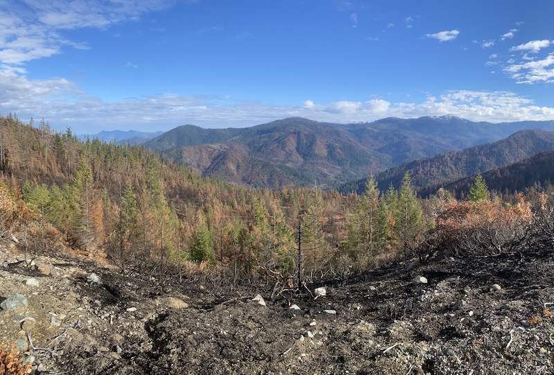
 |
| East Fork Illinois River canyon and the snowy peaks of the Siskiyou Wilderness after the 2020 Slater Fire. Photo credit: Deer Creek Photography |
For the first 24-36 hours the fire burned over 100,000 acres and ripped over the Siskiyou Crest near Bolan Lake. Large swaths of forest on Indian Creek in the Klamath National Forest burned at high severity during this extreme weather event. Relatively large swaths also burned in the headwaters of Althouse Creek and Sucker Creek, near Bolan Lake and Bolan Mountain, as well as in upper Dunn Creek above Takilma, Oregon on the Rogue River-Siskiyou National Forest.
Since the Slater Fire, the Rogue River-Siskiyou National Forest has been logging the Takilma-Happy Camp Road with no public input or oversight. In fact, long before the fire was even considered fully contained, loggers were felling and decking trees along the Takilma-Happy Camp Road, likely using emergency fire suppression funds. Five million board feet of live and dead trees have been removed, including massive old-growth trees which were sold to Swanson Group Manufacturing LLC.
 |
| Forest Service employees stand in front of a Slater Fire log deck sold to Swanson-Superior Lumber. It is troubling to see our public servants standing in front of old-growth trees like trophies. It is also troubling that both live and dead old-growth is being removed with no public oversight along the Takilma-Happy Camp Road. Photo credit: USFS |
Additionally, the Rogue River-Siskiyou National Forest has just proposed a large, post-fire logging project along roads in the Slater Fire area, the project has been slyly named the Slater Fire Safe Re-entry Project. In this project the agency has called for post-fire hazard tree logging along public Forest Service roads at the headwaters of the East Fork Illinois River watershed, from the East Fork Illinois River drainage and Dunn Creek above Takilma, to the headwaters of Althouse Creek and Sucker Creek near Bolan and Tanner Lakes.
Although some level of hazard tree mitigation may be necessary along open Forest Service roads, and we support taking action to address true public safety concerns, this project will go above and beyond by removing both snags and also live green trees up to 200' on either side of open Forest Service roads. The project will create 400' linear clearcuts along 85 miles of road and on 4,106 acres of public land. The agency has estimated that approximately 20 million board feet of timber will be harvested from the Slater Fire area.
According to the Scoping Notice for the project, these treatments will occur in the Bolan Lake Botanical Area, on over 2,000 acres in a large block Late Successional Reserve forest set aside for the protection of the Northern spotted owl, in Designated Backcountry Areas, Riparian Reserves, Special Wildlife Sites, and adjacent to the Red Buttes Wilderness and Siskiyou Wilderness Area boundaries; however, no project design features or mitigation measures were included to ensure consistency with management guidelines in these important conservation areas.

Looking northeast from near the Siskiyou Crest near Bolan Mountain into
the East Fork Bolan Creek Watershed and across the Slater Fire Area.
Photo credit: Deer Creek Photography
Logging treatments proposed in the Slater Fire Safe Re-entry Project would remove all dead standing trees within 200' of a public road, as well as logging potentially large, living trees that survived the Slater Fire. The agency has proposed removing living, green trees based on the level of canopy scorch sustained during the Slater Fire. Unfortunately, the agency is identifying trees with only moderate levels of crown scorch as "dead," and prioritizing them for removal. For example, large sugar pine trees receiving over 55% canopy scorch, large ponderosa and Jeffrey pine receiving over 35% canopy scorch, and large Douglas fir trees with over 70% canopy scorch will all be considered "dead," and logged within 200' of public roads.
The Forest Service is proposing these treatments through the use of a Categorical Exclusion, which will allow them to avoid further public comment periods, site specific scientific analysis, and the full disclosure of the associated impacts. According to the Scoping Notice, 4,106 acres will be treated with hazard tree logging prescriptions, while another 2,662 acres that burned at lower severity are proposed for hazard tree felling, but felled trees will be left on site. In all, 6,768 acres would be treated, exactly 2,568 more acres than are legally allowed under a Categorical Exclusion.
Why are snag forests important?
It is important for the Forest Service to reduce
hazard tree removal areas to the smallest footprint necessary to
protect public safety, while allowing for natural fire regeneration, especially in Late Successional Reserves, Botanical Areas, Designated Backcountry Areas, Riparian Reserves and Special Wildlife Sites. Large
snag patches created by high severity fire leave behind abundant biological legacies in the form of snags and downed wood. These
biological legacies provide structural complexity, build soil, hold
moisture, cast shade and create favorable microclimates for
regenerating forest species. These functions are particularly important because the fire killed trees will create the only input of large diameter snags or downed wood until late successional forest habitats have regenerated in the high severity fire patches of the Slater Fire area.
Snags and living trees in the Slater Fire area are also critically important for wildlife. They provide nesting and denning habitat for a wide variety of wildlife species from bats, insects and song birds, to black bears and the Pacific fisher. If located in proximity to living forest habitats, the Northern spotted owl will also utilize snag patches to forage for dusky footed woodrats. Snag patches attract large populations of white headed woodpeckers that live here at the western edge of their range, and they will provide benefits to wildlife for decades to come.
Research has shown that fire killed trees release carbon slowly over decades and accelerate the development of forest regeneration. On the other hand, post-fire logging releases large volumes of carbon more quickly and hinders the regeneration of complex, carbon rich forests into the future.
Take
action now and send in a comment letter for this important project! Ask the
Forest Service to retain all living trees and protect special
management areas such as LSR forest, Botanical Areas, Wilderness Areas,
Designated Backcountry Areas, Riparian Reserves, and Special Wildlife
Sites in the Slater Fire area. Below are talking points and information
necessary to comment on this project.
 |
| Snow on the Slater Fire near Bolan Lake. Photo credit: Deer Creek Photography |
Talking Points
The following talking points are based on the management guidelines in the Siskiyou National Forest Land & Resource Management Plan, which currently guides management on the Rogue River-Siskiyou National Forest. To abide by these management guidelines, the following minimum measures must be met.
Send comments to the Forest Service by February 18, 2021
Comments can be filed electronically at:
comments-pacificnorthwest-Siskiyou-wildrivers@usda.gov
or
https://cara.ecosystem-management.org/Public//CommentInput?Project=59314
 |
| A view across the Slater Fire from Bear Camp Ridge looking northeast into the East Fork Illinois River and Dunn Creek watersheds. |
 | |
| Looking north from near the summit of Bolan Mountain and Bolan Lake following the 2020 Slater Fire. Photo credit: USFS |
 |
| A view from near the summit of Bolan Mountain north to Bolan Lake and into the Sucker Creek watershed in 1934. This photograph is part of the Osborne Lookout Photo series taken by the Forest Service in the 1930s. It shows historic fire effects that are similar to those of the 2020 Slater Fire. |
The Slater Fire started on the evening of September 7, 2020 as a human or accidental ignition near the Slater Butte Lookout, just three miles east of Happy Camp, California and above the rugged Klamath River canyon. Although it is believed that the fire was started by high voltage power lines owned by Pacific Power, the ignition source has not yet been confirmed by Forest Service fire investigators; however, lawsuits have already been filed against Pacific Power. Regardless of how the fire started, the ignition coincided with unusually strong easterly winds and historically low humidity levels.
By the morning of September 8, the fire was building momentum and spreading rapidly to the west and northwest across the Indian Creek watershed. The fire's giant smoke plume and convection column began creating its own wind, blowing down trees and promulgating even more extreme fire behavior.
During this fire storm, embers thrust ahead of the flaming front created a multitude of spot fires and led to the ignition of many homes. Within hours of the fire's ignition, and with virtually no notice for local residents, the community of Happy Camp was aflame. Unfortunately, the Slater Fire burned with such fury in those early hours that Happy Camp simply did not stand a chance.
Tragically, over 200 homes were lost, doing incredible damage to the small community. Many residents sadly lost their homes and all their belongings in the fire. The weather patterns, the fire intensity, the unbelievable ember shower, and the speed at which the fire approached left many unable to prepare, safely evacuate or effectively defend their homes.
 | |||
| The Slater Fire burning on Slater Butte above Happy Camp on the morning of September 8, 2020. Photo Credit: Mid-Klamath Watershed Council |
By the evening of September 8, the fire had burned over the Siskiyou Crest near Bolan Lake and Bolan Mountain. Throughout the evening the fire continued barrelling down the northern slopes of the Siskiyou Crest towards the Illinois Valley in upper Althouse Creek, Sucker Creek and the East Fork Illinois River watersheds.
Twenty four hours after the Slater Fire began its incredible wind-driven, high severity run, it had already burned approximately 120,000 acres. Unbelievably, the Slater Fire was now burning not only on the slopes above the Illinois River Valley including Sucker Creek, but it had also worked its way north of the recent Eclipse and Natchez Fire footprints, jumped Highway 199 and burned into the Smith River watershed.
By
September 9, the Slater Fire had backed downhill from Bolan Mountain
and Tanner Peak into the Sucker Creek watershed. The winds had died down
considerably, the humidity levels had risen some, and a dense smoke
inversion began to settle in, moderating fire intensity. The
forests of Sucker Creek contain almost no recorded fire history and most
had not burned in over 100 years, yet weather conditions allowed the fire
to burn at largely low severity.
 |
| This fire map from September 21, 2020 demonstrates the influence of recent fire footprints such as the 2017 Eclipes Fire and 2018 Natchez Fire, which became a barrier to the fire's western spread. The Slater Fire is shown in yellow and was surrounded on three sides by recent fire footprints (shown in red and orange). The Slater Fire burned north into unburned terrain near the California/Oregon border. |
Although the Slater Fire will likely be remembered for its big, wind-driven run, and the community of Happy Camp will
forever remember the fire as a tragedy that burned down many homes and
disrupted many lives in the remote Klamath River community, the story of
the Slater Fire is complex and multifaceted.
Like all wildfire, the
Slater Fire was highly diverse and conditional, but this fire was
undoubtedly extreme. For less than two short days the fire raged, leaving a lasting
mark across the southern face of the Siskiyou Crest and the Indian
Creek Watershed. During this dry, windy period vast acreages burned in large swaths of stand replacing fire; however, what is likely to be forgotten is the additional month of slow moving, low to moderate severity fire that burned in the many watersheds feeding the East Fork of the Illinois River, including Sucker Creek.
 |
| A soil burn severity map of the Slater Fire published by the Forest Service. The green polygons denote low severity fire effects, while the yellow denotes moderate severity fire effects, and red depicts high severity fire. Notice the swath of high and moderate severity fire that correlates to the wind-driven firestorm of September 8. These areas sustained very high levels of vegetation mortality. Also take note of the extensive low severity fire effects on Sucker Creek on the northeastern fire perimeter, along Thompson Creek and Thompson Ridge, on the eastern margin, and on the western portion of the fire on East Fork Illinois River and Smith River. |
 |
| This fire progression map published by the Forest Service documents the extent of fire spread in the first two days (shown in purple), while the remaining portions of the fire burned much more slowly. The red, yellow, orange and light blues demonstrates that minimal fire growth was sustained outside the first 24 hour burn window. |
Sucker Creek, the China Left Timber Sale & the Slater Fire
 |
| The Slater Fire backed down steep, heavily forested north-facing slopes as a low severity, understory fire in Sucker Creek. The fire crept down to the southern bank of the Left Fork of Sucker Creek and largely put itself out as it backed into the lush riparian area. |
A stronghold for old-growth forest, the headwaters of Sucker Creek drains both the Siskiyou Crest and the Grayback Range, a high, north-tending spur ridge that divides the headwaters of the Illinois River from the Applegate River watershed. These spectacularly wild headwater streams drain the westernmost portions of the Red Buttes Wilderness Area and the Kangaroo Inventoried Roadless Area.
 | |
| Old-growth Douglas fir on Left Fork Sucker Creek | . |
Sucker Creek supports some of the largest runs of coho salmon remaining in the Rogue River basin, and was designated a key watershed under the Northwest Forest Plan. Large portions of Sucker Creek have also been designated as a Late Successional Reserve for the benefit of the Northern spotted owl and other wildlife species requiring old-growth and late successional forest habitats.
I personally have a special affinity for Sucker Creek because it was one of the first watersheds I worked to defend. While just a teenager growing up in southern Oregon, I spent two summers blockading roads and timber sale units in the notorious China Left Timber Sale. This old-growth timber sale was originally approved under the 1989 Hatfield/Adams Rider that allowed ancient forest logging to continue in Northern spotted owl habitat without judicial review. In 1991, the Ninth Circuit Court authorized an injunction delaying award of the sale, and in 1993 the timber sale was withdrawn when Fish and Wildlife deemed the project's impact on Northern spotted owl Critical Habitat "unacceptable."
In 1995, President Clinton signed the Salvage Rider, which was attached without congressional debate to a spending bill authorizing relief for Bosnian refugees and victims of the horrific Oklahoma City bombing. The infamous Salvage Rider exempted so-called "salvage" and "forest health" timber sales from environmental laws, allowing many old-growth logging projects to move forward, including the China Left Timber Sale high on the slopes above Sucker Creek.
 |
| A t-shirt printed with the Sucker Creek Free State logo. |
The Sucker Creek Free State was a backwoods protest camp precluding access to old-growth timber sale units on the Left Fork Sucker Creek. A series of trenches and debris piles of wood and rock were piled up in the roadbed. The gate at the bottom of the road was permanently closed and activists created a series of cement and stone barricades extending up road 4612-080 to Limestone Creek, where an old, rusted pontiac was taken off its wheels and placed across the roadway.
Each barricade included metal locking devices that allowed activists to lock their wrists into metal pins cemented into the ground. This allowed them to peacefully and effectively block access to the logging units above using non-violent civil disobedience. Wooden tripods were also erected with tipi poles where activists could sit dangerously perched high above the roadbed, also blocking passage to motor vehicles, bulldozers and/or logging equipment. The idea was to risk significant bodily harm if authorities attempted to remove you, thus protecting the old-growth forests above.
 |
| Siskiyou Forest Defenders logo |
On New Years Eve, heavy warm rains fell on deep mountain snow unleashing floods, debris flows and landslides across the Siskiyou Mountains. On Sucker Creek, Forest Service road 4612-080 blew out in numerous locations and throughout the spring and summer of 1997 activists worked to disrupt road reconstruction, blockade the timber sale units and disrupt logging operations with varying levels of success.
In the end, after two years of peaceful civil disobedience and the hard work of hundreds of local residents and activists, successful litigation over impacts to threatened coho salmon canceled the timber sale. Yet, when the court finally intervened, only approximately 50 of the 530 acres approved for logging remained standing.
Although at the time the Forest Service insisted, amid great controversy, that China Left must be logged to increase forest health and reduce future fire severity, the actual effects of the project lie in stark contrast to the cynical claims of the agency. Unfortunately, the legacy of this false narrative continues today as federal land managers increasingly log intact native forest habitats in the name of "forest health" or "fuel reduction."
 |
| Although the agency claimed to be logging the China Left Timber Sale for "forest health," the devastation is clearly evident 20 years later in 2017. |
The China Left Timber Sale included 12.7 million board feet of old-growth timber, including 274 acres of clearcut logging and 256 acres of selective old forest logging. Units included Late Successional Reserve forest, Riparian Reserves, old forests near Horse Mountain, and old-growth logging units on the edge of the Kangaroo Inventoried Roadless Area on Left Fork Sucker Creek.
Ironically, following the Slater Fire it has become evident that both the China Left Timber Sale units and other logging units in the area burned at much higher severity than the surrounding unmanaged forests. In fact, these logged over areas created some of the only high severity fire effects on the ridgeline dividing the Right Hand Fork from the Left Fork Sucker Creek (see the photo essay below).
Although in the end it was a minor victory, a major inspiration and a devastating loss, the China Left Timber Sale, taught me to love, defend and embrace the forests of the Siskiyou and set me on the path I follow to this day.
 |
| The lush Port Orford-cedar and Douglas fir forests in Left Fork Sucker Creek burned at low severity in the Slater Fire, blackening the massive, old trunks, but maintaining the tall, green canopy. |
Recently, I explored the beautiful Left Fork Sucker Creek Trail from Kester Mine to Brush Creek on the Slater Fire's northeastern perimeter. The Slater Fire burned the entire Right Hand Fork Sucker Creek, and over the tall, forested ridge extending down from Swan Mountain, only to smolder out at the water's edge on the lush southern bank of the Left Fork Sucker Creek.
Although I had not hiked this wild canyon in many years and it had just burned in the Slater Fire, it was in fact, the same spectacular canyon of lush, old-growth forest I had remembered. The forests between Kester Mine and Brush Creek consist of massive Port Orford-cedar, girthy Douglas fir and sugar pine, along with tall, wide-branching tanoak, live oak, madrone and chinquapin. These forests grow like a cathedral above the banks of Left Fork Sucker Creek as it pours through dark boulders, rushes down small bedrock shoots, quietly glides through riffles and cascades off the stream's abundant instream wood into clear, cold plunge pools.
The rugged canyon of Left Fork burned in the understory, while maintaining the spectacular multi-layered canopy so important for the Northern spotted owl. While the canopy remains almost uniformly green, the forest floor is a mosaic of burned black soils, charcoal covered nurse logs and unburned patches of lush green moss, rhododendron, huckleberry, Oregon grape and vine maple.
 |
| The low severity fire effects in Left Fork Sucker Creek maintained cool, moist microclimate conditions, while depositing additional woody debris into the stream corridor that will benefit fisheries. |
Before the fire, Left Fork Sucker Creek already contained the largest concentration of instream wood in the watershed, with some reaches containing over 400 pieces per stream mile. During the fire, additional trees and snags burned, fell to the forest floor and into the rushing creek, creating complex habitat for the native steelhead that travel this far upstream. These downed trees also create structure, maintain pool habitat and help to provide cold, clear mountain water that sustains the mainstem of Sucker Creek during the dry summer months.
 |
| Looking up Right Hand Fork Sucker Creek to the tall, forested ridgeline extending east towards Swan Mountain, with fire effects from the Slater Fire. |
In just a few years, the signs of understory fire in the Left Fork canyon will soften as lush green growth again swallows the forest floor. Freshly burned cavities and catfaces will provide vital denning habitat for the Pacific fisher and hibernating black bear. New cavities chiseled by pileated woodpeckers into soft, fire-killed snags will become abundant nesting habitat for a multitude of species. Broken top snags will provide resting perches for local raptors; large populations of white headed woodpeckers will feast on the insects, grubs and beetle larva attracted to freshly killed snags, and standing Douglas fir trees that survived the fire will support the red tree vole.
Life will go on as it always has in the upper reaches of Sucker Creek. The forests will continue to stand tall in the canyons, provide habitat for a wide variety of forest species, and shade the watershed's rushing streams.
The Sucker Creek watershed remains largely unchanged
following the Slater Fire. Complex old forest and dense canopy still
dominates the upper canyon, providing habitat for the Northern spotted
owl, Pacific fisher, and goshawk, while providing cold, clean water for
the important runs of coho salmon that spawn downstream.
The Slater Fire is essentially a tale of two separate
fires: the wind-driven inferno of September 8 that will leave a lasting legacy of fire-killed snags across the landscape, and the slow moving, understory fire that
dominated the rest of the active fire period and burned in the understory at the headwaters of Sucker Creek.
 |
| Left Fork Sucker Creek tumbles down the western slope of the Grayback Range at the northeastern margin of the Slater Fire. |
 |
The north and south slope of the Siskiyou Crest near Bolan and Tanner Lake after the 2020 Slater Fire. Notice the vast stand replacing fire on the southern slopes of the Siskiyou Crest at the headwaters of Indian Creek. This area sustained significant wind-driven, high severity fire effects on September 8, 2020. Also notice the more mixed fire mosaic with significant green forest on the north slope of the Siskiyou Crest at the headwaters of Sucker Creek and at the top of the image. These slopes were somewhat sheltered from the strong winds on September 8, and large portions of the Sucker Creek watershed burned at low to moderate severity under a heavy smoke inversion, cooler temperatures, higher humidity levels and minimal winds after the big wind event. |
 |
| Upper Indian Creek and the Siskiyou Crest near Bolan and Tanner Lakes in 2018, before the Slater Fire. |
 |
| The same image as above showing upper Indian Creek and the Siskiyou Crest near Bolan and Tanner Lakes, after the 2020 Slater Fire. |
 |
| The Upper Sucker Creek watershed in 2018 (facing south) before the Slater Fire. Bolan Lake is the big blue lake at the right corner of the image, while Tanner Lakes are located near the top at the left. |
 | |
| The same image after the Slater Fire at the headwaters of Sucker Creek. Notice the mixed severity fire mosaic with significant understory fire. Also take note that nearly every visible logging unit burned at high severity. |
 | ||
| Fire effects at Tanner Lakes and Right Hand Fork Sucker Creek in the Red Buttes Wilderness, and the flank of Swan Mountain in the Kangaroo Inventoried Roadless Area following the Slater Fire. |
 |
| A close up of Tanner Lakes in the Red Buttes Wilderness Area showing a mixed severity fire mosaic. |
 |
| An aerial view of Thompson Ridge after the Slater Fire showing a strong contrast in burn severity. The western face of Thompson Ridge in the Indian Creek watershed (left) was affected by high winds and burned at high severity on September 8, 2020. The eastern face of the ridge draining into Thompson Creek (right) burned at low severity as the fire backed downhill against the strong winds, creating very little overstory tree mortality. |
 |
| A 1993 aerial image of upper Sucker Creek directly below the Kangaroo Inventoried Roadless Area and Red Buttes Wilderness Area, and before the China Left Timber Sale. The image shows Swan Mountain and portions of both the Right Hand Fork Sucker Creek and portions of Left Fork Sucker Creek. Notice the patchwork of clearcuts and the selective logging near the center of the image with clear skyline yarding corridors. The large clearcuts at the top of the photo were cut in 1974, while the remaining logging was implemented in 1991. |
 |
| The same location in 1998 following implementation of the China Left Timber Sale. Notice the extensive logging of old-growth forest that occurred in the upper 1/3 of the image during the summer of 1997. This fresh logging is a particularly devastating portion of the China Left Timber Sale. Also notice the landslide triggered by the rectangular clearcut at the center of the image. This landslide let loose during the 1997 New Year's Flood. |
 |
| The same location as above in November 2020, after the Slater Fire. Notice how the high severity fire effects are concentrated in previous logging units, including the China Left Timber Sale, the selectively harvested unit and staggered clearcuts from 1991, and the rectangular clearcut at the center of the image. |
 |
| KFA field monitoring on the Shasta Agness Timber Sale above the Wild & Scenic Rogue River discovered a previously unknown Northern spotted owl within commercial units in the Shasta Agness Timber Sale. The discovery of this owl is forcing the Forest Service to remove significant acreage from the timber sale's Decision Record. |
Klamath Forest Alliance has been busy in 2020 fighting for the wildlands of the Klamath-Siskiyou Mountains and building a movement to protect, defend and restore the natural world. Despite the hardships of 2020, we remain focused on the needs of the land and our commitment to protect the wild watersheds that surround us, and the forests that are critical for carbon sequestration and climate defense.
During these difficult times, more than ever, wildlands provide us solace. They provide a sense of humility and awe, a place of quiet reflection, and a place of inspiration. They are an escape from the increasingly stressful and unhealthy modern world, and they are the building blocks for a more sustainable future. Despite the importance of wildlands, they are increasingly threatened with mining, logging, grazing, off-road vehicle use and other forms of ecologically destructive public land management.
The Siskiyou Field Office of Klamath Forest Alliance is committed to defending the uniquely diverse, spectacularly rugged, and stunningly beautiful watersheds along the border of southwestern Oregon and northwestern California. This post highlights the work of KFA in 2020 as well as the projects and issues we expect to address in 2021.
Crawford Timber Sale
 |
| The forests of the Crawford Timber Sale have been saved by KFA litigation. |
The Crawford Timber Sale was proposed by the Klamath National Forest in a vital connectivity corridor between the Siskiyou Crest and the Marble Mountains Wilderness Area. Located on the Klamath River downstream from Happy Camp, California and along the eastern margin of the Siskiyou Wilderness Area, this timber sale would have logged off the habitat of four Northern spotted owl pairs by removing 139 acres of Critical Habitat. The project also proposed the "incidental take" (i.e. sanctioned killing through waivers provided by the US Fish & Wildlife Service) of two of the last Northern spotted owls known to be reproducing on the Klamath River, and would have negatively impacted important anadromous fisheries.
In 2020, KFA and our conservation allies filed suit to stop the Crawford Timber Sale and protect occupied habitat for the Northern spotted owl. After filing our lawsuit, the Klamath National Forest withdrew the timber sale and we are cautiously optimistic that the project has been canceled for good. We will continue monitoring the activities of the Klamath National Forest in 2021, and if necessary, we will continue fighting for these owls and the critical habitat they need for their survival.
Shasta Agness Timber Sale
 | |
| The spotted owl discovered by KFA field monitors. |
The Shasta Agness Timber Sale proposes to log an estimated 24 million board feet of timber, including over 15,000 large trees between 20" and 28" in diameter. Despite the heavy logging proposed, the Forest Service failed to adequately survey for the threatened Northern spotted owl. In July 2020, on-the-ground monitoring efforts by KFA discovered a previously unknown Northern spotted owl population within the proposed logging units. The discovery of this owl is forcing the Forest Service to remove approximately 630 acres of commercial logging units from the final Decision Record for the Shasta Agness project. The agency has also agreed to drop an additional 88 acres of proposed "serpentine pine" logging treatments based on the input of KFA and our conservation allies.
We will continue tracking the Shasta Agness Timber Sale in 2021 and working to protect the forests and wildlife of the Siskiyou Wild Rivers region.
Integrated Vegetation Management for Resilient Lands Projects (IVM)
The Integrated Vegetation Management for Resilient Lands (IVM) Project is one of the worst federal land management projects proposed in southwestern Oregon for many years. The project envisions industrial logging throughout nearly the entire Medford District BLM, including 634,185 acres of proposed "treatment areas." Under the provisions proposed in the IVM Project the agency could log up to 20,000 acres and build up to 90 miles of new road per decade without additional public comment or site specific scientific review. To make matters worse, this project is specifically targeting Late Successional Reserve (LSR) forest designated to protect habitat for the Northern spotted owl.
If approved, this project will impact forests, wildlands, wildlife and fisheries across our region. It also proposes to exclude the public from the public land management planning process. In 2021, KFA will make the IVM Project a priority and will work with grassroots and rural conservation advocates throughout the Applegate, Rogue and Illinois River watersheds to oppose this project.
Late Mungers Timber Sale
 |
| A unit proposed for logging in the Late Mungers Timber Sale. |
Throughout 2021 KFA will be working with partners in southwestern Oregon to oppose the Late Mungers Timber Sale and protect this important connectivity corridor.
Bear Grub Timber Sale
 |
| A Bear Grub Timber Sale unit located in the Wellington Wildlands. |
The Bear Grub Timber Sale, located in the mountains between Talent in the Rogue Valley and Ruch in the Applegate Valley, proposes industrial logging on 1,100 acres. This includes 293 acres inside the Wellington Butte Roadless Area (known locally as Wellington Wildlands). The project also includes logging units along the popular East Applegate Ridge Trail, a beautiful non-motorized trail through the foothills of the Applegate Valley. Logging prescriptions include group selection logging, a form of staggered clearcut logging that will increase fire risks, degrade wildlife habitat, and release large volumes of stored carbon. Unfortunately, the project was approved by the BLM and sold at the federal timber auction.
KFA will continue working to STOP BEAR GRUB in 2021.
Wild & Scenic River Protections
 |
| The proposed Wild & Scenic Middle Fork Applegate River. |
In 2020, KFA worked with Applegate Neighborhood Network (ANN) to promote our Wild & Scenic Applegate River proposal. We identified approximately 200 miles of proposed Wild & Scenic River on public lands in the serpentine canyons of Slater Creek, the wild headwaters of the Upper Applegate River, the woodlands of the Little Applegate River canyon and cedar lined Pipe Fork Williams Creek. We worked throughout 2020 to document the "Outstandingly Remarkable Values," map our proposals, promote our proposals, and advocate for the permanent protection of worthy Siskiyou Mountain streams.
To secure permanent Wild & Scenic River designation on the Applegate River will require continued advocacy in 2021. KFA will be working in 2021 with a statewide coalition of environmental activists, supportive members of the public, and elected officials to secure Wild & Scenic River designation.
Wildfire Advocacy
 |
| Slater Fire fire effects at Bolan Lake on the Siskiyou Crest. |
We tracked the Red Salmon Complex burning on the Salmon Divide from July 27 to late October of 2020. This fire burned at the headwaters of New River deep in the Trinity Alps Wilderness and in wild tributaries the Salmon River. Despite our advocacy, the Forest Service bulldozed fireline on Packsaddle Ridge inside the wilderness boundary. In 2021, we will work to document the impact of wilderness bulldozing and fire suppression activities in the Red Salmon Fire Report.
KFA supports the protection of communities from wildfire impacts and the protection of wildland values from inappropriate fire suppression activities. During the upcoming 2021 fire season we will track the regional wildfires wherever they may be and advocate for ecologically appropriate and operationally effective wildland fire management strategies. We will work hard to maintain wildland values, protect intact watersheds, promote the responsible management of wildland fire, restore fire as a natural process through wildland fire management, and advocate for more effective protection of communities at risk to wildfire impacts.
OHV Closures

In 2020 we also petitioned the Wild Rivers Ranger District on the Rogue River-Siskiyou National Forest to secure the closure of numerous illegal routes entering roadless habitats and crossing streams in areas with Port Orford cedar that are currently uninfected by the deadly, non-native pathogen, Port Orford cedar root rot (Phytophthora lateralis). Port Orford cedar root rot is carried uphill and between watersheds in mud on vehicle tires. Once introduced into a drainage it will spread downhill, especially along streams, attacking and killing Port Orford cedar trees. The risk of infection from these illegal OHV routes is extremely high and we are proactively advocating for closure of these damaging routes before it is too late. We hope to see these routes closed or at least approved for closure in 2021.
Finally, we worked to close approximately 3 miles of illegal motorized trail in a small roadless area on the Modoc National Forest located in the Medicine Lake Highlands above Lava Beds National Monument. This route was illegally built through beautiful old-growth lodgepole pine forests and up steep volcanic slopes of pumice, cinder and other highly erosive volcanic rocks to the summit of a spectacular mountain peak. The route was causing severe harm to the surrounding ecosystem and hundreds, if not thousands, of lodgepole pine trees were illegally felled to build the route. KFA documented these impacts and petitioned the Modoc National Forest for route closure. To their credit, Forest Service staff responded promptly with physical closure efforts. In 2021, we hope to revisit the Modoc National Forest to monitor this closure and work to secure more OHV closures.
Forest Legislation
KFA has been actively engaged in advocacy surrounding legislative efforts in the state of Oregon to address issues surrounding wildfire and forest management. In 2020 we testified in front of the Oregon State Committee on Forests and Fire Management and submitted detailed, science-based comments to proposed legislative efforts affecting the forests of the Siskiyou Mountains.
We have also submitted extensive written comments directly to Oregon state senators exploring fire ecology, fire science, and potential legislative solutions that will restore fire as a natural process in our forests, while more effectively protecting lives, homes, communities and infrastructure in wildfire events.
Looking Forward to 2021
 |
| Traveler's gentian (Gentiana calycosa) blooming on the Siskiyou Crest. |
In 2021 KFA will work towards the protection of worthy streams in the Applegate Watershed with permanent Wild & Scenic River protections. We will also defend against a wide variety of immediate threats to the wildlands of the Klamath-Siskiyou Mountains. From the Wild Rivers Coast to the arid foothills of the Applegate Valley, across the spine of the Siskiyou Crest and into the wild watersheds of the Mid-Klamath Watershed, the Siskiyou Field Office of Klamath Forest Alliance will continue working to protect, defend and restore the natural world. We are among the most passionate and committed advocates of the Klamath-Siskiyou! Please help us defend the beautiful Siskiyou Mountains and consider a generous year-end, tax-deductible donation to support our work. Together we can protect the last intact habitats in the Siskiyou Mountains!
 |
| The Wild and Scenic Rogue River flows through BLM lands west of Grants Pass, Oregon. |
The Bureau of Land Management (BLM) manages more public land than any other federal land management agency, including nearly 248 million acres, representing an incredible 10.5% of all land in the United States. These public lands contain important wildlife habitat, highly scenic landscapes and many spectacular wildlands.
In the Siskiyou Mountains, BLM lands include the Medford District BLM, which manages the Cascade-Siskiyou National Monument, the foothills of the Applegate Valley, diverse forests in the Illinois River watershed, and portions the spectacular Wild and Scenic Rogue River.
Unfortunately, during the Trump Administration, the BLM has declared an all-out assault on both public involvement and environmental regulations, implementing an undemocratic, unscientific and industrial approach to public land management. This has facilitated an increase in damaging projects across the West, including increased logging, mining, drilling, grazing, off-road vehicle use, and more.
Although historically poor stewards of our public lands and biased in favor of industrial resource extraction, under the Trump Administration the last shreds of integrity at BLM have been drastically eroded. In fact, the BLM has been fully transformed into an illicit, rogue agency that is openly hostile to public land and the conservation values it was intended to protect. From the highest level political appointees, down to local BLM offices, anti-public land ideology and private extractive industries have thoroughly corrupted the agency.
 |
| BLM logging in the Sterling Sweeper Timber Sale. |
Illegal Political Appointees & Corruption at the Highest Levels
Led by the illegally appointed, anti-public lands extremist William Perry Pendley, the BLM currently serves as a resource base for private industry, not a public agency working for the greater public good.
Pendley formerly worked as a mining and oil industry attorney and as president of the Western States Legal Foundation, funded by both the Charles Koch Foundation and Exxon Mobil. Before being appointed to his illegal tenure as BLM director, Pendley regularly sued the BLM, advocating for privatization and the industrial exploitation of public resources. He has also denied the existence of climate change, advocated for the illegal killing of endangered species, and written numerous books promoting anti-public land ideology.
 |
| Diverse landscapes like the Cascade-Siskiyou National Monument are managed by the Medford District BLM. Early in the Trump Administration the agency proposed eliminating protections for portions of the Cascade-Siskiyou National Monument, but appears to have backed away from that proposal. |
Yet, despite a history of hostility towards the BLM, or perhaps because of it, the Trump Administration initially proposed Pendley for the Director position in July of 2019. Knowing that Pendley's extremist views would preclude senate confirmation, this nomination was quickly withdrawn and the Trump Administration simply declared him the "acting" BLM director, a position that has been repeatedly renewed, making his "acting" role essentially permanent. For over one and a half years, Pendley, illegally acting as BLM Director, set policy and priorities designed specifically to undermine public lands, public involvement and public accountability.
In response, Montana Governor Steve Bullock sued the federal government over the appointment of Pendley as BLM Director without appropriate confirmation or oversight. In the end, Judge Brian Morris of the US District Court deemed Pendley's appointment unlawful, directed him to immediately step down, and suggested that land management decisions and policy changes made during his tenure should be either thrown out or reversed.
Backed by the Trump Administration, and in open violation of the law, Pendley has refused to step down, stating that the ruling would have "no impact whatsoever." Currently, Pendley continues to dictate policy, dismantle the agency and sacrifice public lands to his industry allies.
Local Impacts, Policy Changes and Contempt for both the Environment and the Public
 |
| Wellington Wildlands on BLM lands in the Applegate Valley is not only an unprotected roadless area, but portions of the wildland are threatened with BLM logging in the Bear Grub Timber Sale. |
Although policy makers and BLM officials in Washington DC seem far from the Siskiyou Mountains and the forests of Western Oregon, their impact has been felt here in our local region and across our local BLM lands. During the Trump Administration and the illegal tenure of Pendley, the management of local BLM lands has become significantly less inclusive, responsive or accountable to the public, and projects themselves have become significantly more industrial in nature.
The specific environmental rollbacks enabling this shift include:
These significant changes in national and regional policy have translated directly into impacts to our local forests and communities. They have also facilitated a complete breakdown in trust between the BLM and the public in our region, hearkening back to the "timber wars" of the 1990s.
 |
| Large, old trees like these are proposed for logging in the controversial Bear Grub Timber Sale. This timber sale was proposed, approved and sold to the timber industry with virtually no public involvement under the policies of William Perry Pendley. |
More than happy to embrace the Trump era and lock the public out of the public land planning process, the Medford District BLM has begun aggressively and inappropriately implementing their 2016 Resource Management Plan under this new veil of secrecy. Projects such as the Bear Grub Timber Sale, Clean Slate Timber Sale, Griffin Halfmoon Timber Sale, Poor Windy Timber Sale, and the innocuous sounding Integrated Vegetation Management for Resilient Lands Project (IVM) have been proposed or approved without adequate public involvement, without adequate scientific analysis and with absolutely no honest attempt to show concern for public values, community fire safety, wildlife habitats, recreational values, wildlands, or non-timber related economic values.
What these projects do have in common is a general contempt for the values, needs and concerns of surrounding communities and an increase in "regeneration," group selection, or clearcut logging.
The implementation of these types of industrial logging will significantly increase fire hazards adjacent to our communities and contribute to a warming climate. Commercial logging is the largest producer of greenhouse gases in the state of Oregon (Law. 2018), and by removing large, old trees, BLM timber sales will release abundant stored carbon into the atmosphere. BLM logging projects are actively degrading carbon-rich primary forests, altering larger climate patterns and localized micro-climate conditions, damaging wildlife habitats, impacting recreation areas, non-timber related economic values and the quality of life for residents of southwestern Oregon.
The Need for Reform
 |
| Public meetings and field trips like this one in 2014 for the Nedsbar Timber Sale are currently a thing of the past. Instead of engaging local communities, the Medford District BLM is working to avoid accountability and manage public resources for the sole benefit of private industry. |
Our forests and communities deserve better! Comprehensive reform, restructuring, and realignment of the BLM is badly needed. The recent change in administrations makes this reform both possible and timely, but it also depends on local activists, residents and those that recreate on BLM land speaking up, speaking out and demanding change. It also requires that elected officials on all levels work to reform the BLM and define a new way forward by:
1) Replacing Secretary Bernhardt, "acting" director William Perry Pendley, and other compromised BLM officials with nominees that value public land, support conservation, acknowledge the threat of climate change and will work on behalf of both the land and the people of this country, not just the corporations.
2) Withdrawing all Trump era NEPA rule changes, strengthening public involvement standards and increasing scientific review standards for all NEPA projects. We recommend implementing NEPA reforms that are specifically targeted towards making public land management more transparent, scientifically sound, inclusive, responsive to public concerns, and environmentally responsible
3) Banning all new oil and gas drilling leases on public lands nationwide. Review, and when necessary withdraw, Trump era oil and gases leases on sensitive lands including the Arctic National Wildlife Refuge.
4) Extend the 2001 Roadless Rule to BLM lands nationwide, including all BLM Wilderness Study Areas, uninventoried roadless areas and Lands with Wilderness Characteristics (LWC).
5) Reinstate the protections for the Bears Ears and Grand Staircase-Escalate National Monuments removed by the Trump Administration in 2017.
6) Require all federal land management projects to analyze climate impacts during the NEPA process.
7) Strengthen and expand the Endangered Species Act (ESA), and specifically increase protections for the Northern spotted owl from "threatened" to "endangered." Reinstate and expand Northern spotted owl critical habitat designations on Western Oregon BLM lands.
8) Repeal the O&C Act and manage public lands in Western Oregon for carbon sequestration, wildlife habitat, water quality, fisheries, recreation, connectivity, and biodiversity.
9) Create large carbon reserves on public forest lands throughout the West, and protect all late successional and old growth forest habitats for climate mitigation and carbon storage.
10) Designate new National Monuments and National Recreation Areas across the country, including the Siskiyou Mountains National Recreation Area on Medford District BLM lands and the Siskiyou Crest National Monument on adjacent National Forest lands.